


Le Mesnil-Eudes

Eve - Line
User
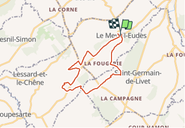

Length
12.8 km

Max alt
179 m

Uphill gradient
154 m
Km-Effort
14.9 km

Min alt
99 m

Downhill gradient
153 m
Boucle
Yes
Creation date :
2022-01-23 07:20:14.406
Updated on :
2022-01-23 09:54:21.438
2h32
Difficulty : Easy

FREE GPS app for hiking
 SityTrail
IGN / Geographical institutes
SityTrail Plus
The world is yours!
About
Trail Walking of 12.8 km to be discovered at Normandy, Calvados, Le Mesnil-Eudes. This trail is proposed by Eve - Line.
Description
Départ salle des fêtes
Photos


Positioning
Country:
France
Region :
Normandy
Department/Province :
Calvados
Municipality :
Le Mesnil-Eudes
Location:
Unknown
Start:(Dec)
Start:(UTM)
294133 ; 5441643 (31U) N.
Comments